|
Advertisement / Annons: |
My travels in Sweden:
|
Contents:
|
|
You can use the maps from Stockholmskällan. It has the function that you can compare maps from different years. It's only one map that cover the areas outside Stockholm City, the map from 1934. |
|
Now its summer and much nicer to take walks, this time we took a walk from Fåfängan to Slussen in Stockholm. I have added links with deeper information, most of them are Wikipedia links. I have chosen the Swedish link, but in some cases you can shift to English. If there is no English version you can use Google translator or similar service. There are more information in the Swedish language. Harbors from Fåfängan to Slussen:Map over our walk:From Fåfängan to Slussen, it's about a 5 km long walk. Henriksdal, Nacka:
To get to Fåfängan we took the bus from Slussen and jump off at Henriksdal, it took less then ten minutes. 
From here we have a short walk back to Södermalm where Fåfängan is placed. A bridge take us over to the other side of the road. The street on this bridge has the name Hästholmsvägen (Horse road). From the bridge in Southern direction we have a view over Henriksdalsberget. More to read about Henriksdalberget at Wikipedia:

At the other direction from the bridge, North we see two bridges, the bridge to the right is Danviksbron, built 1922. 1956 they added one more bridge, the left one. 
We was lucky to came just when they open the bridge. More to read about Danviksbron at Wikipedia:

The passenger boat Kanholmen pass under the bridge. Fåfängan:
You see the square of trees up there, that's Fånfängan. But before we climb up there we follow the harbor to the right. Danviksklippan:
A view over the canal and Danviksklippan on the other side. This canal was built in the 1930s, to right the old road to Stockholm was placed before they blow away the rock. It was a lake before 3 meters above the sea level, Hammarbysjön or Hammarby Lake. More to read about Hammarby sjö at Wikipedia:
|
|
Advertisement / Annons: |
Danviksbron:
We take the staircase down to sea level. 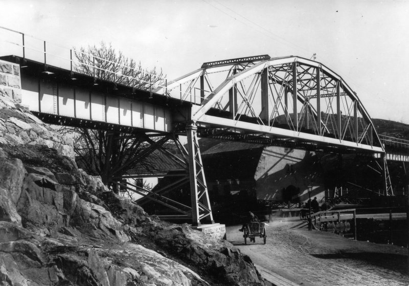 Kredit: SSnJ Stockholm-Saltsjöns Järnväg, Viadukten vid Danvikstull. Stockholm-Stadsgården Fotograf: Okänd, unknown (resized, cropped) I found this photo of the old bridge from 1893, at bottom must be the road that lead to Stockholm City. More to read about railway Saltsjöbanan at Wikipedia:

Here we found the railway, not many years ago you could take tours with a Diesel locomotive around these industry railways in Stockholm. Now it's blocked for traffic. 
There is also a tunnel for cars and other vehicles. Closest to us is the tunnel below the "new" bridge from 1956. 
The control tower to the bridge, nowadays it's remote operated. When I worked at the company Siemens they delivered a new control systems to this bridge, maybe in the 1980s. 
Long time ago Stockholm had a lot of steam boats crossing the seas, then they disappeared. Now in recent years they have started trafficking the sea and lakes with boats again, some of them are electric with batteries. Danvikens Hospital:
At this place before the canal it was a building belong to the Danviken's hospital across the small river from the lake Hammarbysjön. The yellow building to the left is the Danviken's hospital, in front a nice restaurant. More to read about Danvikens hospital at Wikipedia:
Saltsjöqvarn:
The building with red bricks is Saltsjöqvarn, a mill. Now it's rebuilt to a hotel. More to read about Saltsjöqvarn at Wikipedia:

|
Harbor Masthamnen:
This harbor has the name Masthamnen, in the background across the sea we have Djurgården. 
The inner part of Baltic Sea. More to read about Masthamnen at Wikipedia:

The ship Albatros has anchored here today. Coal storage:
We still have steamships crossing the sea. They have their coal supply here. 

A view back to Saltsjöqvarn once again. 
Maybe this once was a customs office. 
The colored lines helps the tourists where to go, green line to hop on hop off ferries. |

This is the other side of the railway tunnel, blocked also from this side. 
A custom office too ? 
Now it's time for us to leave the harbor and climb up to Fåfängan, in the beginning we follow the green line backwards. 

Fåfängan:
A sign tell us the way to walk up to Fåfängan. I didn't know that it was a walk path on the backside of the hill. Good, now we save a lot of steps. 
A view from the hill, in background the ski hill Hammarbybacken, the hill built of garbage. 
The demolished house was earlier a bus and subway museum, even earlier it was a bus garage. |
|
Advertisement / Annons: |

The bridge where the tram run earlier, what they shall use it for in the future I don't know. There are so much going on in Stockholm City nowadays. 
Down there was once one of Sweden's biggest shipyards, at that time it was a bay. You can find the yellow building on the photo from 1902 below, also the church towers are easy to find. 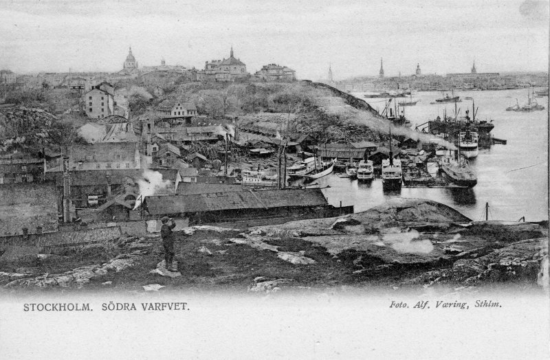 Kredit: Södra Varvet 1902, Stockholm. Överblick. Sjöhistoriska Museet Fotograf: Vaering, Alf (resized) More to read about W. Lindbergs Varvs- och Verkstads AB at Wikipedia:

The pleasure park Gröna Lund in background. More to read about Gröna Lund at Wikipedia:


Now we have Fåfängan above us on top of the hill. More to read about Fåfängan at Wikipedia:

View from Fåfängan: Saltsjöqvarn and Danviksberget that we just passed. 
Northeast, somewhere here it has been a fortress building. Harbor Masthamnen:
Back down to the harbor Masthamnen, now we heading Eastern direction to Slussen. |
Viking Ferry terminal:
These Viking Lines ferries have their rout to Finland and the island Åland. 
A lot of people living in Stockholm take these ferries over the weekend. Stadsgården:
On top of the hill, Ersta Hospital. Big parts of the rock has been blasted away. More to read about Ersta Sjukhus at Wikipedia:
My sister worked at this hospital many years and I too have some connection to it with my missions. 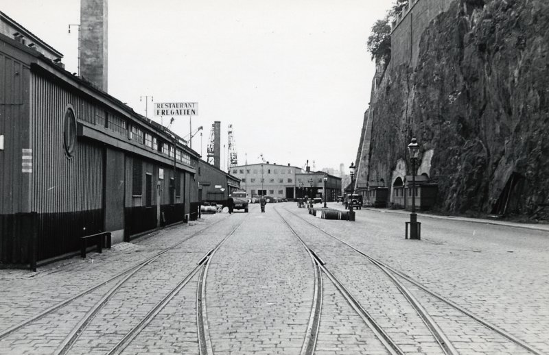 Kredit: Restaurang Fregatten i Stadsgården. Fotograf: Okänd, unknown (resized, cropped) About the same view from 1930s. 
Modern ships are big compared to what I grew up with in the 1960s. This part of the harbor is called Stadsgården. 
An old steamship passing by. More to read about Stadsgården at Wikipedia:
Customs house:
On the left side the old customs house. 

Hop on hop off boat. |

Today the customs house is used to photography exhibitions. More to read about Fotografiska at Wikipedia:
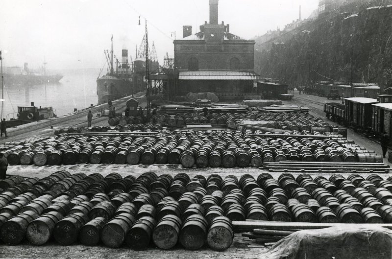 Kredit: Stockholm, Stadsgården. Fotograf: Ransell, Karl (K. A.) (resized, cropped) Photo from 1920 with oil barrels in front of the customs house. The ship M/S Birger Jarl:
This ship with the name M/S Birger Jarl has belonged to Stockholm and cruises to the island Åland during many years. Today it isn't allowed to go out at the sea, it was to expensive to rebuilt to todays safety standard. Now they use it as a hotel. 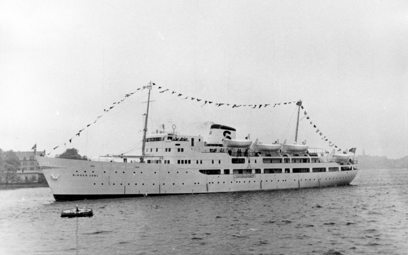 Kredit: Stockholm Strömmen, S/S Birger Jarl 1953-06-04 Fotograf: Norberg, Oscar (1882 - 1961) (resized, cropped) Photo from 1953 when S/S Birger Jarl was new and equipped with a steam machine. Look how different it looked when it was new. 
I have many memories from this ship. Last time I traveled with M/S Birger Jarl I took some photos, about ten years ago: Birger Jarl cruise. 
It's also a restaurant and a pub on this ship. Perfect, we need a rest after this walk and it will be very interesting to revisit the ship. 
We took a glass of wine and a toast. At the upper deck it was crowded, we asked two young girls at the table if we can sit down. These two girls were very nice, they told us they had come from Borlänge to Stockholm to visit a concert with the band Eagle. A music group both I and Gunilla enjoyed in the 1980s. They also told us that they too had a music band where they sing and play guitar in. 
On the top of the wall to the left is the street Fjällgatan, very popular tourist place with a grand view over the sea. It has a lot of history too. More to read about Fjällgatan Stockholm at Wikipedia:

The elevator Stadsgårdshissen. The third elevator along the harbor, the two others are Katarinahissen and Mariahissen. None of them are in work today, but maybe they will restore Katarinahissen. More to read about Stadsgårdshissen at Wikipedia:

|
|
Advertisement / Annons: |

We have a short walk left from here to Slussen, time to leave Birger Jarl. More to read about the ship M/S Birger Jarl at Wikipedia:
The sign M/S tells us that it's a Motor (diesel) Ship, but when it was new it was a steamship, S/S. 
Next ship, it must have been a big party onboard this ship, loud disco music. New Slussen:
The lock Karl Johan Slussen are during reconstruction, a big project that will take many years. A temporary office building to the workers has been setup here. 
The brown brick house is Sjömansinstitutet (Seafarer institution). More to read about the house Sjömansinstitutet at Wikipedia:
Maybe my father was in contact with the staff here when he was a seafarer from 1937 to 1945. 
Among other things they has to rebuilt the staircase. 

Gamla Stan (Old Town) in front of us. 
This is the KF-house. More to read about the KF-huset at Wikipedia:
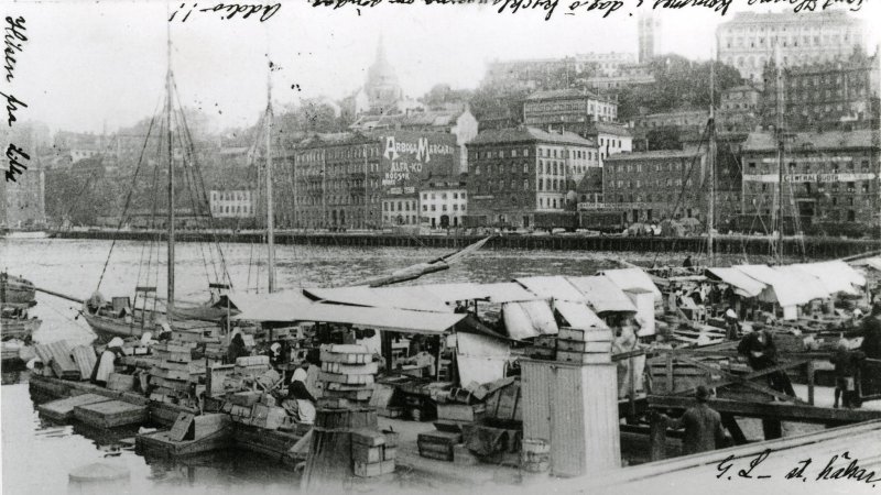 Kredit: Fiskarehamnen och Stadsgården i Stockholm ca 1904. Fotograf: okänd, unknown (resized, cropped) Photo from 1904 before the new buildings, it's a little bit more to the left. |

The elevator Katarinahissen, this is the second generation elevator here, built 1933. More to read about Katarinahissen at Wikipedia:

With this we have finished our walks along the harbors at Södermalm. If you want to read more about Slussen I have a page here. 
The Last walk through the tunnels. 
This ramp lead us up to Gamla Stan (Old Town).
|
| Go Back |